OpenStreetMap Data Model
Objectives:
- Understanding Concept of tag, key, dan value in OpenStreetMap
- Knowing OpenStreetMap wiki page as a guideline for key and value
- Understanding Objects which can be mapped into OpenStreetMap
- Knowing and Understanding data model as a part of mapping preparation plan
- Checking specific key and value in TagInfo website
In this module, you will learn about key and value concept in OpenStreetMap (OSM) as well as data model in OSM objects. Knowing about data model will help you to prepare your mapping activity plan efficiently start from planning, field survey and input the field survey data. You also learn some websites which can help you to find specific information key and value that you need based on OpenStreetMap standard.
I. Tag, Key, dan Value Concept
In OpenStreetMap there are 3 types of object. They are: Nodes, Ways, and Polygon/Closedways. Each type of data has information that can represent the object. That information called Tag which structured by key and value.
For instance, there is a school in your area. Therefore, the school should be Tagged as a school in OpenStreetMap. The school’s tag has some details information that make the school being different from other schools. Those information such as name, address, building level, school type, etc. In OpenStreetMap, they are Key while each information of them called Value.
Example of School Tag:
name=SDN Kebon Manggis 11 Pagi
address= Jalan Slamet Riyadi II.
In the example above, “name and address” are Key while “SDN Kebon Manggis 11 Pagi and Jalan Slamet Riyadi II” are Value. See the image below to see the explanation in OpenStreetMap website:
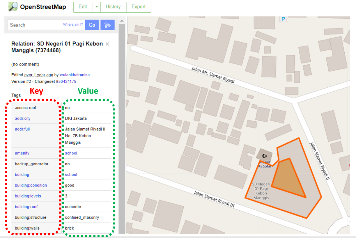
As you can see on the picture above, key and value always written in english according to the OpenStreetMap standard. You do not need to remember all key and value in OpenStreetMap because you can find them in wikipedia OpenStreetMap website which will be explained in this module.
II. Wikipedia OpenStreetMap to see Key and Value
As a one of mapping participatory platform, OpenStreetMap has millions of contributors all around the globe. Therefore to produce and ensure a good quality data and information in OpenStreetMap, the contributors together established rules and standardization guidelines and put into one open-source platform site called wikipedia.
a. Global Wikipedia OpenStreetMap
Further explanation and list of key and value in OpenStreetMap have been made and put into specific OSM wikipedia page called Map Feature. In this page, you can search and find any key and value that used in OpenStreetMap globally. To access this page please visit at: https://wiki.openstreetmap.org/wiki/Map_Features
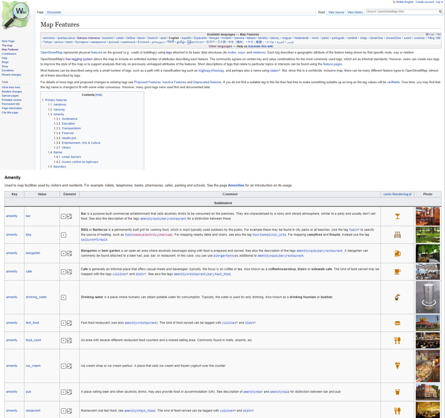
Every key and value in this page is absolute and has been standard information for any object that you want to map in OpenStreetMap and cannot be changed or modified as you want. Therefore, this page is a guideline for all OSM contributors all over the world to find any information about their mapping object in OpenStreetMap.
b. Indonesia OpenStreetMap Wikipedia
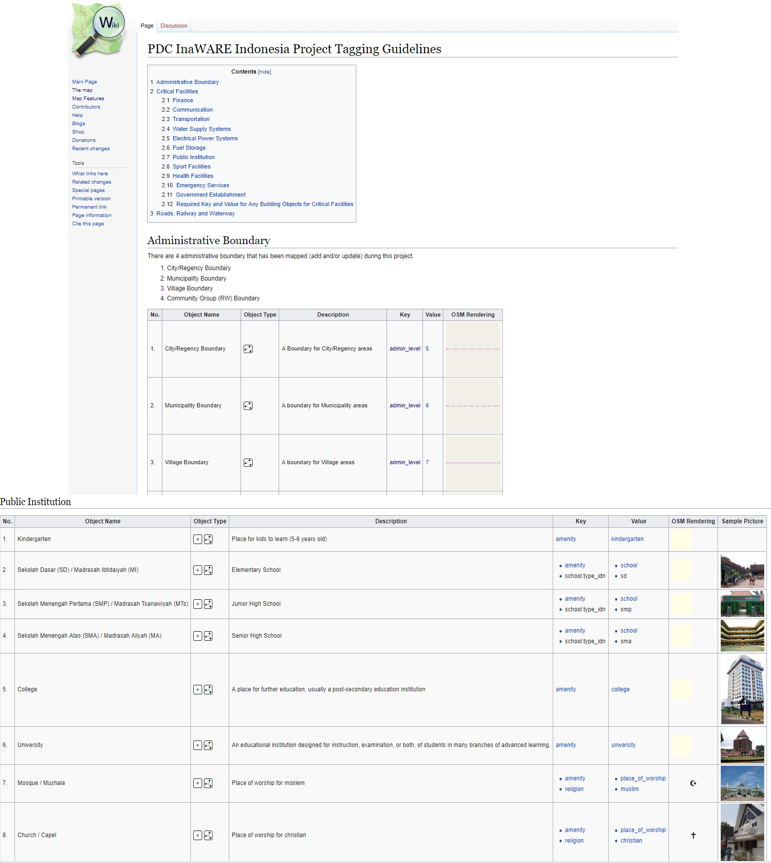
Number of OSM Contributors in Indonesia has been increasing in recent years. As one of biggest OSM contributors in the world, Indonesia OSM contributors need a guideline about key and value information especially particular information for objects in Indonesia. However, they are usually difficult to find a tag that match with the mapping object. There are so many information in the Map Feature page yet sadly most of them are unneeded or unnecessary for objects in Indonesia. Moreover, object’s name in Map Feature often can not be recognized by OSM contributors in Indonesia because it is using global name while Indonesia using local name. Therefore, Humanitarian OpenStreetMap Team (HOT) Indonesia made another page in OSM wikipedia that shows specific information about key and value mapping objects in Indonesia as a guideline for Indonesia OSM contributors.
Main difference between Map Features and Indonesia OSM Wikipedia page is list of the mapping objects. While Map Features shows all information for mapping objects all over the world, Indonesia OSM Wikipedia only showing information about objects in Indonesia and some of them do not available in the map feature. For instance, schools in Indonesia have various information including types of school start usually called SD (elementary school), SMP (junior high school) and SMA (senior high school). Health facilities also has various type depending of its type such as Rumah Sakit (Hospital), Puskesmas ( hospital in village level) , Posyandu (hospital in rural area). These information are essential in Indonesia therefore they have been placed in Indonesia OpenStreetMap Wikipedia page. Another example is you only can find name kiosk as a name and key of small store in Map Feature while the name is not familiar and known by most of Indonesian in Indonesia OpenStreetMap Wikipedia page this small store has been given a local name called “warung” even though still has key=kiosk for its tag in OpenStreetMap.
You can see list of objects information in Indonesia OpenStreetMap Wikipedia page by click this link: https://wiki.openstreetmap.org/wiki/Id:Indonesian_Tagging_Guidelines
III. Mapping Objects in OpenStreetMap
a. Data types in OpenStreetMap
In this module, you have been explained about data types in OpenStreetMap: point (Nodes), line (Ways) and area (Polygon/Relation). These are further explanation of each data type in OpenStreetMap.
- Point (Nodes)
Point usually being used to represent position or location of certain object. For instance, objects which drawn as a point (nodes) in OpenStreetMap such as traffic light, gas station or restaurant in a mall or shopping center.
- Line (Ways)
Line is an object that is formed by sequence of points (nodes) which connect one to another. Some objects which usually drawn as a line in OpenStreetMap such as road, river, railway and administration boundary.
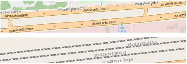
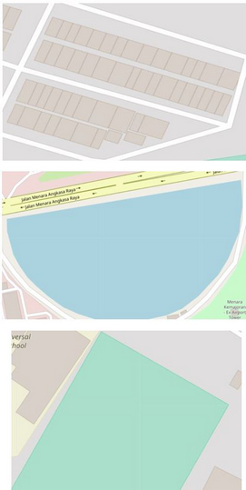
- Area (Polygon)
Area is formed by sequence of lines (ways) which connect one to another. Some objects in OpenStreetMap such as building, park, land use and lake are drawn as area.
b. Mapping Objects in HOT-PDC Project
In OpenStreetMap, you can map any object on earth surface as long as it is real and permanent. Real means that the object has physical form and can be seen such as building and roads whereas non-real object such as high level or population density. Permanent means the object has specific location and not moving in particular time.
Choosing what objects that we want to map in OpenStreetMap depends on the purposes of the mapping project itself. In HOT-PDC InAWARE, the purpose is to collecting critical infrastructures which can be used for disaster management. These are list of objects that has been mapped into OpenStreetMap in HOT-PDC InAWARE project:
1.Economic Facilities
- Traditional Market
- Supermarket
- Bank
2. Education Facilities
- University
- College
- School (SD, SMP, SMA)
- Kindergarten
3. Health Facilities
- Hospital
- Clinic
4. Communication
- Communication Tower
5. Emergency Service
- Police Office
- Fire Station
- Evacuation Center
- Hydrant
6. Government
- Government Office (Governor, Mayor, District, Sub-district, village and sub-village office)
- Embassy
- Government Institution (Ministry)
7. Electricity
- Power tower
- Power substation
- Power Plant
8. Transportation
- Airport
- Bus Station
- Train Station
- Harbour / Dock
9. Public Facilities
- Place of Worship (Mosque, Church, Temple)
- Sport Facility (Sport Center, Stadium, Sports Field)
- Public Spaces
10. Water
- Water Tower
- Water Gate
- Pump House
- Embankment
- River
- Lake / Dam
11. Gas Station
12. Administration Boundary
- City / District Boundary
- Sub-district boundary
- Village boundary
- Sub-village boundary
13. Road Network
IV. Data Mapping Model in OpenStreetMap
Data model is a compilation of some information for an object where consisted from key and value in OpenStreetMap. A data model does not have a standard for what information that should be put in an object. The model should be followed the purposes of mapping project. For instance, if you want to map school in you area and you need information of school name, address, school type, school operator, and building level then your data model should be like this:
School Tag Information Table
| key | (possible) values |
|---|---|
| amenity | school |
| building | school |
| school:type_idn | sd [SD/MI (Elementary School)], smp [SMP/MTs (Junior High School)], sma [SMA/SMK/MA (Senior High School)] |
| name | (building name) |
| addr:full | (address) |
| operator:type | government, private, community |
| building:levels | (number of building floor) |
amenity=school is a compulsory tag for the school information. Key and value in this tag are main information that identify the object as a school.
building=school is a tag that show the school has its own building. Some schools are located in another building such as government office area therefore if that was the case then this tag is unnecessary.
a. HOT-PDC InAWARE Data Model
The purpose of HOT-PDC InAWARE mapping project is to gather information of critical infrastructures in context of disaster management. Therefore, you need to create data model that can help the survey team to collect the information in the field and upload them into OpenStreetMap. These are data model for each priority object in HOT-PDC InaWARE mapping project:
Color Information:
- Blue color means the key and value are compulsory for the object.
- Red color means the key and value are information for building of the object. This tag /information only collected if the object has its own building. Otherwise, the tag is unnecessary.
- Black color means the key and value should be added regardless the object has its own building or not.
1.Economic Facilities
- Table of Traditional Market Data Model
| key | possible values |
|---|---|
| amenity | marketplace |
| building | marketplace |
| name | (traditional market name) |
| addr:full | (address) |
| addr:city | (mapping city) |
| capacity:persons | <50, 50-100, 100-250, 250-500, >500 |
| building:levels | (number of building floor) |
| building:structure | confined_masonry , steel_frame , wood_frame , bamboo_frame |
| building:material | brick , concrete , wood , bamboo , glass |
| building:floor | ground, wood, cement, tekhel, ceramics |
| building:roof | tile, tin, asbestos, concrete |
| access:roof | yes, no |
| building: condition | poor, good |
| ground_floor:height | (building base floor height from the road (meter unit)) |
| backup_generator | yes, no |
| source | HOT_InAWARESurvey_2018 |
- Table of Supermarket Data Model
| key | possible values |
|---|---|
| amenity | supermarket |
| building | supermarket |
| name | (supermarket name) |
| addr:full | (address) |
| addr:city | (mapping city) |
| capacity:persons | <50, 50-100, 100-250, 250-500, >500 |
| building:levels | (number of building floor) |
| building:structure | confined_masonry , steel_frame , wood_frame , bamboo_frame |
| building:material | brick , concrete , wood , bamboo , glass |
| building:floor | ground, wood, cement, tekhel, ceramics |
| building:roof | tile, tin, asbestos, concrete |
| access:roof | yes, no |
| building: condition | poor, good |
| ground_floor:height | (building base floor height from the road (meter unit)) |
| backup_generator | yes, no |
| source | HOT_InAWARESurvey_2018 |
- Table of Bank Data Model
| key | possible values |
|---|---|
| amenity | bank |
| building | bank |
| name | (bank name) |
| addr:full | (address) |
| addr:city | (mapping city) |
| capacity:persons | <50, 50-100, 100-250, 250-500, >500 |
| building:levels | (number of building floor) |
| building:structure | confined_masonry , steel_frame , wood_frame , bamboo_frame |
| building:material | brick , concrete , wood , bamboo , glass |
| building:floor | ground, wood, cement, tekhel, ceramics |
| building:roof | tile, tin, asbestos, concrete |
| access:roof | yes, no |
| building: condition | poor, good |
| ground_floor:height | (building base floor height from the road (meter unit)) |
| backup_generator | yes, no |
| source | HOT_InAWARESurvey_2018 |
2. Education Facilities
- Table of University Data Model
| key | possible values |
|---|---|
| amenity | university |
| building | university |
| name | (university name) |
| addr:full | (address) |
| addr:city | (mapping city) |
| operator:type | government, private, community |
| capacity:persons | <50, 50-100, 100-250, 250-500, >500 |
| building:levels | (number of building floor) |
| building:structure | confined_masonry , steel_frame , wood_frame , bamboo_frame |
| building:material | brick , concrete , wood , bamboo , glass |
| building:floor | ground, wood, cement, tekhel, ceramics |
| building:roof | tile, tin, asbestos, concrete |
| access:roof | yes, no |
| building: condition | poor, good |
| ground_floor:height | (building base floor height from the road (meter unit)) |
| backup_generator | yes, no |
| source | HOT_InAWARESurvey_2018 |
| evacuation_center | yes, no |
| shelter_type | tent, building |
| water_source | water_works, manual_pump, powered_pump |
| kitchen:facilities | yes, no |
| toilet:facilities | yes, no |
| toilets:number | (number of toilets) |
- Table of College Data Model
| key | possible values |
|---|---|
| amenity | college |
| building | college |
| name | (college name) |
| addr:full | (address) |
| addr:city | (mapping city) |
| operator:type | government, private, community |
| capacity:persons | <50, 50-100, 100-250, 250-500, >500 |
| building:levels | (number of building floor) |
| building:structure | confined_masonry , steel_frame , wood_frame , bamboo_frame |
| building:material | brick , concrete , wood , bamboo , glass |
| building:floor | ground, wood, cement, tekhel, ceramics |
| building:roof | tile, tin, asbestos, concrete |
| access:roof | yes, no |
| building: condition | poor, good |
| ground_floor:height | (building base floor height from the road (meter unit)) |
| backup_generator | yes, no |
| source | HOT_InAWARESurvey_2018 |
| evacuation_center | yes, no |
| shelter_type | tent, building |
| water_source | water_works, manual_pump, powered_pump |
| kitchen:facilities | yes, no |
| toilet:facilities | yes, no |
| toilets:number | (number of toilets) |
- Table of School Data Model (SD, SMP, SMA)
| key | possible values |
|---|---|
| school:type_idn | sd (Elementary School)], smp (Junior High School)], sma (Senior High School) |
| amenity | school |
| building | school |
| name | (school name) |
| addr:full | (address) |
| addr:city | (mapping city) |
| operator:type | government, private, community |
| capacity:persons | <50, 50-100, 100-250, 250-500, >500 |
| building:levels | (number of building floor) |
| building:structure | confined_masonry , steel_frame , wood_frame , bamboo_frame |
| building:material | brick , concrete , wood , bamboo , glass |
| building:floor | ground, wood, cement, tekhel, ceramics |
| building:roof | tile, tin, asbestos, concrete |
| access:roof | yes, no |
| building: condition | poor, good |
| ground_floor:height | (building base floor height from the road (meter unit)) |
| backup_generator | yes, no |
| source | HOT_InAWARESurvey_2018 |
| evacuation_center | yes, no |
| shelter_type | tent, building |
| water_source | water_works, manual_pump, powered_pump |
| kitchen:facilities | yes, no |
| toilet:facilities | yes, no |
| toilets:number | (number of toilets) |
- Table of Kindergarten Data Model
| key | possible values |
|---|---|
| amenity | kindergarten |
| building (Early education / Play group / Kindergarten) | school |
| name | (kindergarten name) |
| addr:full | (address) |
| addr:city | (mapping city) |
| operator:type | government, private, community |
| capacity:persons | <50, 50-100, 100-250, 250-500, >500 |
| building:levels | (number of building floor) |
| building:structure | confined_masonry , steel_frame , wood_frame , bamboo_frame |
| building:material | brick , concrete , wood , bamboo , glass |
| building:floor | ground, wood, cement, tekhel, ceramics |
| building:roof | tile, tin, asbestos, concrete |
| access:roof | yes, no |
| building: condition | poor, good |
| ground_floor:height | (building base floor height from the road (meter unit)) |
| backup_generator | yes, no |
| source | HOT_InAWARESurvey_2018 |
3. Health Facilities
- Table of Hospital Data Model
| key | possible values |
|---|---|
| amenity | hospital |
| building | hospital |
| name | (hospital name) |
| addr:full | (address) |
| addr:city | (mapping city) |
| operator:type | government, private, community |
| capacity:persons | <50, 50-100, 100-250, 250-500, >500 |
| building:levels | (number of building floor) |
| building:structure | confined_masonry , steel_frame , wood_frame , bamboo_frame |
| building:material | brick , concrete , wood , bamboo , glass |
| building:floor | ground, wood, cement, tekhel, ceramics |
| building:roof | tile, tin, asbestos, concrete |
| access:roof | yes, no |
| building: condition | poor, good |
| ground_floor:height | (building base floor height from the road (meter unit)) |
| backup_generator | yes, no |
| source | HOT_InAWARESurvey_2018 |
| evacuation_center | yes, no |
| shelter_type | tent, building |
| water_source | water_works, manual_pump, powered_pump |
| kitchen:facilities | yes, no |
| toilet:facilities | yes, no |
| toilets:number | (number of toilets) |
- Table of Clinic Data Model
| key | possible values |
|---|---|
| amenity | clinic |
| building | clinic |
| name | (clinic name) |
| addr:full | (address) |
| addr:city | (mapping city) |
| operator:type | government, private, community |
| capacity:persons | <50, 50-100, 100-250, 250-500, >500 |
| building:levels | (number of building floor) |
| building:structure | confined_masonry , steel_frame , wood_frame , bamboo_frame |
| building:material | brick , concrete , wood , bamboo , glass |
| building:floor | ground, wood, cement, tekhel, ceramics |
| building:roof | tile, tin, asbestos, concrete |
| access:roof | yes, no |
| building: condition | poor, good |
| ground_floor:height | (building base floor height from the road (meter unit)) |
| backup_generator | yes, no |
| source | HOT_InAWARESurvey_2018 |
| evacuation_center | yes, no |
| shelter_type | tent, building |
| water_source | water_works, manual_pump, powered_pump |
| kitchen:facilities | yes, no |
| toilet:facilities | yes, no |
| toilets:number | (number of toilets) |
4. Communication
| key | possible values |
|---|---|
| man_made | tower |
| tower:type | communication |
| name | (tower name) |
| height | (tower height in meter unit) |
| operator | Telkomsel, Indosat, XL, Tri, Smartfren |
| communication:mobile | yes, no |
| communication:radio | yes, no |
| addr:city | (mapping city) |
| source | HOT_InAWARESurvey_2018 |
5. Emergency Services
- Table of Police Office Data Model
| key | possible values |
|---|---|
| amenity | police |
| building | police |
| name | (police office name) |
| addr:full | (address) |
| addr:city | (mapping city) |
| capacity:persons | <50, 50-100, 100-250, 250-500, >500 |
| building:levels | (number of building floor) |
| building:structure | confined_masonry , steel_frame , wood_frame , bamboo_frame |
| building:material | brick , concrete , wood , bamboo , glass |
| building:floor | ground, wood, cement, tekhel, ceramics |
| building:roof | tile, tin, asbestos, concrete |
| access:roof | yes, no |
| building: condition | poor, good |
| ground_floor:height | (building base floor height from the road (meter unit)) |
| backup_generator | yes, no |
| source | HOT_InAWARESurvey_2018 |
- Table of Fire Station Data Model
| key | possible values |
|---|---|
| amenity | fire_station |
| building | fire_station |
| name | (fire station name) |
| addr:full | (address) |
| addr:city | (mapping city) |
| capacity:persons | <50, 50-100, 100-250, 250-500, >500 |
| building:levels | (number of building floor) |
| building:structure | confined_masonry , steel_frame , wood_frame , bamboo_frame |
| building:material | brick , concrete , wood , bamboo , glass |
| building:floor | ground, wood, cement, tekhel, ceramics |
| building:roof | tile, tin, asbestos, concrete |
| access:roof | yes, no |
| building: condition | poor, good |
| ground_floor:height | (building base floor height from the road (meter unit)) |
| backup_generator | yes, no |
| source | HOT_InAWARESurvey_2018 |
- Table of Hydrant Data Model
| key | possible values |
|---|---|
| emergency | fire_hydrant |
| fire_hydrant:type | underground, pillar, wall, pond |
| name | (hydrant name) |
| operator | (operator name) |
| addr:city | (mapping city) |
| source | HOT_InAWARESurvey_2018 |
6. Government
- Table of Government Office Data Model Model (Governor, Mayor, District, Sub-district, village and sub-village office)
| key | possible values |
|---|---|
| office | government |
| building | governor_office, townhall, subdistrict_office, village_office, community_group_office |
| admin_level | 4 (for governor office), 5 (for townhall), 6 (for subdistrict office), 7 (for village office), 9 (for community group office) |
| name | (government office name) |
| addr:full | (address) |
| addr:city | (mapping city) |
| capacity:persons | <50, 50-100, 100-250, 250-500, >500 |
| building:levels | (number of building floor) |
| building:structure | confined_masonry , steel_frame , wood_frame , bamboo_frame |
| building:material | brick , concrete , wood , bamboo , glass |
| building:floor | ground, wood, cement, tekhel, ceramics |
| building:roof | tile, tin, asbestos, concrete |
| access:roof | yes, no |
| building: condition | poor, good |
| ground_floor:height | (building base floor height from the road (meter unit)) |
| backup_generator | yes, no |
| source | HOT_InAWARESurvey_2018 |
| evacuation_center | yes, no |
| shelter_type | tent, building |
| water_source | water_works, manual_pump, powered_pump |
| kitchen:facilities | yes, no |
| toilet:facilities | yes, no |
| toilets:number | (number of toilets) |
- Table of Government Institution Data Model (Ministry)
| key | possible values |
|---|---|
| office | government |
| building | government_office |
| name | (government institution name) |
| addr:full | (address) |
| addr:city | (mapping city) |
| admin_level | 4 (provincial level), 5 (city level), 6 (subdistrict level), 7 (village level) |
| capacity:persons | <50, 50-100, 100-250, 250-500, >500 |
| building:levels | (number of building floor) |
| building:structure | confined_masonry , steel_frame , wood_frame , bamboo_frame |
| building:material | brick , concrete , wood , bamboo , glass |
| building:floor | ground, wood, cement, tekhel, ceramics |
| building:roof | tile, tin, asbestos, concrete |
| access:roof | yes, no |
| building: condition | poor, good |
| ground_floor:height | (building base floor height from the road (meter unit)) |
| backup_generator | yes, no |
| source | HOT_InAWARESurvey_2018 |
7. Electricity
- Table of Power Tower Data Model
| key | possible values |
|---|---|
| power | tower |
| name | (tower name) |
| addr:city | (mapping city) |
| operator | PT Perusahaan Listrik Negara |
| source | HOT_InAWARESurvey_2018 |
- Table of Power Sub Station Data Model
| key | possible values |
|---|---|
| power | substation |
| substation | transmission, distribution |
| building | power_substation |
| name | (power substation name) |
| addr:city | (mapping city) |
| rating | (user defined) |
| operator | PT Perusahaan Listrik Negara |
| source | HOT_InAWARESurvey_2018 |
- Table of Power Plant Data Model
| key | possible values |
|---|---|
| power | plant |
| building | power_plant |
| name | (power plant name) |
| operator | (power plant operator) |
| addr:city | (mapping city) |
| addr:full | (address) |
| source | HOT_InAWARESurvey_2018 |
8. Transportation
- Table of Airport Data Model
| key | possible values |
|---|---|
| amenity | aerodrome |
| building | aerodrome |
| name | (airport name) |
| addr:full | (address) |
| addr:city | (mapping city) |
| capacity:persons | <50, 50-100, 100-250, 250-500, >500 |
| building:levels | (number of building floor) |
| building:structure | confined_masonry , steel_frame , wood_frame , bamboo_frame |
| building:material | brick , concrete , wood , bamboo , glass |
| building:floor | ground, wood, cement, tekhel, ceramics |
| building:roof | tile, tin, asbestos, concrete |
| access:roof | yes, no |
| building: condition | poor, good |
| backup_generator | yes, no |
| source | HOT_InAWARESurvey_2018 |
- Table of Bus Station Data Model
| key | possible values |
|---|---|
| amenity | bus_station |
| name | (bus station name) |
| addr:full | (address) |
| addr:city | (mapping city) |
| source | HOT_InAWARESurvey_2018 |
- Table of Train Station Data Model
| key | possible values |
|---|---|
| amenity | station |
| name | (train station name) |
| ele | (train station's height above sea level) |
| operator | PT Kereta Api Indonesia |
| addr:full | (address) |
| addr:city | (mapping city) |
| source | HOT_InAWARESurvey_2018 |
- Table of Harbour / Dock Data Model
| key | possible values |
|---|---|
| amenity | ferry_terminal |
| building | ferry_terminal |
| name | (ferry terminal name) |
| addr:full | (address) |
| addr:city | (mapping city) |
| capacity:persons | <50, 50-100, 100-250, 250-500, >500 |
| building:levels | (number of building floor) |
| building:structure | confined_masonry , steel_frame , wood_frame , bamboo_frame |
| building:material | brick , concrete , wood , bamboo , glass |
| building:floor | ground, wood, cement, tekhel, ceramics |
| building:roof | tile, tin, asbestos, concrete |
| access:roof | yes, no |
| building: condition | poor, good |
| backup_generator | yes, no |
| source | HOT_InAWARESurvey_2018 |
9. Public Facilities
- Table of Place of Worship Data Model
| key | possible values |
|---|---|
| amenity | place_of_worship |
| religion | muslim, christian, hindu, buddhist, confucian |
| name | (place of worhsip name) |
| addr:full | (address) |
| addr:city | (mapping city) |
| building | mosque, church, temple |
| capacity:persons | <50, 50-100, 100-250, 250-500, >500 |
| building:levels | (number of building floor) |
| building:structure | confined_masonry , steel_frame , wood_frame , bamboo_frame |
| building:material | brick , concrete , wood , bamboo , glass |
| building:floor | ground, wood, cement, tekhel, ceramics |
| building:roof | tile, tin, asbestos, concrete |
| access:roof | yes, no |
| building: condition | poor, good |
| ground_floor:height | (building base floor height from the road (meter unit)) |
| backup_generator | yes, no |
| source | HOT_InAWARESurvey_2018 |
| evacuation_center | yes, no |
| shelter_type | tent, building |
| water_source | water_works, manual_pump, powered_pump |
| kitchen:facilities | yes, no |
| toilet:facilities | yes, no |
| toilets:number | (number of toilets) |
- Table of Sport Facilities (Sports Center,Sport Field, Stadium)
| key | possible values |
|---|---|
| leisure | stadium, sports_centre, pitch |
| building | stadium, sports_centre, yes (futsal field) |
| name | (sport facility name) |
| addr:full | (address) |
| addr:city | (mapping city) |
| sport | soccer,futsal,basketball,badminton,tennis,volleyball,swimming,athletics, baseball,cycling, multi |
| capacity:persons | <50, 50-100, 100-250, 250-500, >500 |
| building:levels | (number of building floor) |
| building:structure | confined_masonry , steel_frame , wood_frame , bamboo_frame |
| building:material | brick , concrete , wood , bamboo , glass |
| building:floor | ground, wood, cement, tekhel, ceramics |
| building:roof | tile, tin, asbestos, concrete |
| access:roof | yes, no |
| building: condition | poor, good |
| ground_floor:height | (building base floor height from the road (meter unit)) |
| backup_generator | yes, no |
| source | HOT_InAWARESurvey_2018 |
| evacuation_center | yes, no |
| shelter_type | tent, building |
| water_source | water_works, manual_pump, powered_pump |
| kitchen:facilities | yes, no |
| toilet:facilities | yes, no |
| toilets:number | (number of toilets) |
- Table of Park Data Model
| key | possible values |
|---|---|
| leisure | park |
| name | (park name) |
| addr:full | (address) |
| addr:city | (mapping city) |
| source | HOT_InAWARESurvey_2018 |
| evacuation_center | yes, no |
| shelter_type | tent, building |
| water_source | water_works, manual_pump, powered_pump |
| kitchen:facilities | yes, no |
| toilet:facilities | yes, no |
| toilets:number | (number of toilets) |
10. Waterway Facilities
- Table of Water Tower Data Model
| key | possible values |
|---|---|
| man_made | water_tower |
| name | (water tower name) |
| operator | (water tower operator) |
| addr:city | (mapping city) |
| source | HOT_InAWARESurvey_2018 |
- Table of Flood Gate Data Model
| key | possible values |
|---|---|
| waterway | floodgate |
| name | (flood gate name) |
| operator | (flood gate operator) |
| floodgate:unit | (number of floodgate) |
| elevation | (flood gate's height above sea level) |
| condition | good, poor |
| addr:city | (mapping city) |
| source | HOT_InAWARESurvey_2018 |
- Tabel Model Data Rumah Pompa
| key | possible values |
|---|---|
| man_made | pumping_station |
| building | pumping_station |
| name | (pumping station name) |
| addr:full | (address) |
| addr:city | (mapping city) |
| operator | (operator name) |
| pump:unit | (number of pumping station) |
| elevation | (pumping station's height above sea level) |
| capacity:persons | (pump's capacity (l/s)) |
| building:levels | (number of building floor) |
| building:structure | confined_masonry , steel_frame , wood_frame , bamboo_frame |
| building:material | brick , concrete , wood , bamboo , glass |
| building:floor | ground, wood, cement, tekhel, ceramics |
| building:roof | tile, tin, asbestos, concrete |
| access:roof | yes, no |
| building: condition | poor, good |
| ground_floor:height | (building base floor height from the road (meter unit)) |
| backup_generator | yes, no |
| source | HOT_InAWARESurvey_2018 |
- Table of Embankment Data Model
| key | possible values |
|---|---|
| man_made | embankment |
| name | (embankment name) |
| material | concrete, stone, soil, sand |
| source | HOT_InAWARESurvey_2018 |
- Table of River Data Model
| key | possible values |
|---|---|
| waterway | river, riverbank, canal |
| name | (river) |
| width | (river width) |
| source | HOT_InAWARESurvey_2018 |
- Table of Reservoir Data Model
| key | possible values |
|---|---|
| landuse | reservoir |
| name | (resevoir/lake name) |
| operator | (operator name) |
| addr:city | (mapping city) |
| source | HOT_InAWARESurvey_2018 |
11. Gas Station
- Table of Gas Station Data Model
| key | possible values |
|---|---|
| amenity | fuel |
| name | (gas station name) |
| addr:full | (address) |
| addr:city | (mapping city) |
| operator | (PT Pertamina, Shell, etc) |
| source | HOT_InAWARESurvey_2018 |
12. Administration Boundary
| key | possible values |
|---|---|
| type | boundary |
| boundary | administrative |
| name | (boundary name) |
| admin_level | 4 (Province), 5 (City / District), 6 (Sub-district), 7 (Village), 8 (Hamlet), 9 (Sub-village), 10 (Sub-sub village) |
| is_in:province | (province name) |
| is_in:city (city) / is_in:town (district) | (city/subdistrict name) |
| is_in:municipality | (sub-district name) |
| is_in:village | (village name) |
| is_in:RW | (sub village name) |
| flood_prone *only for sub village relation | yes, no |
| landslide_prone *only for sub village relation | yes, no |
| source | HOT_InAWARESurvey_2018 |
13. Road Network
| key | possible values |
|---|---|
| highway | motorway, trunk, primary, secondary, tertiary, service, residential, pedestrian, path, living_street, track |
| name | (street name) |
| layer | 5,4,3,2,1,-1,-2,-3,-4,-5 |
| width | (road width) |
| lanes | (number of road lanes) |
| surface | asphalt, concrete, metal, wood, grass, ground, gravel, mud, sand, paving_stones |
| smoothness | good, intermediate, bad, impassable |
| motorcycle | yes, no |
| oneway | yes, no |
| ref | (refference) |
| source | HOT_InAWARESurvey_2018 |
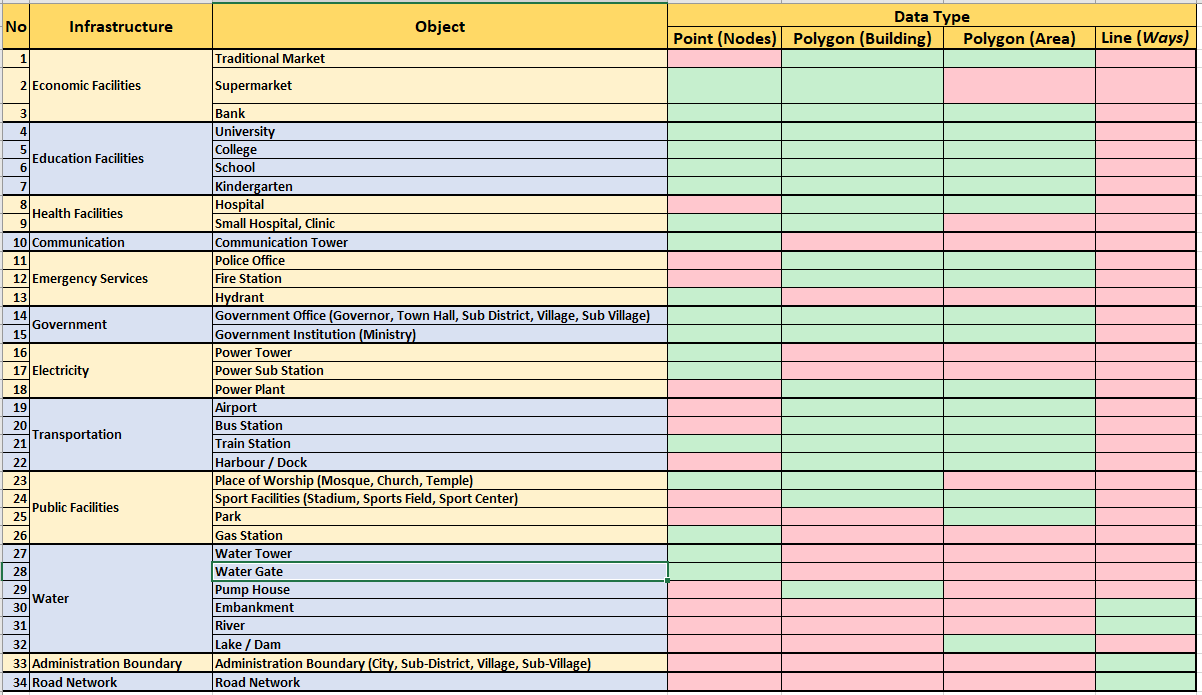
b. Data Type in OpenStreetMap Based on Object
After knowing data model based on object tag in OpenStreetMap particularly in HOT-PDC InAWARE Project, you also need to know data type based on the object itself. The table below shows you what type of data for each object that you can add into OpenStreetMap:
Color Information:
- Green Color means the object allowed to be mapped in that data type.
- Red Color means the object not allowed and prohibited to be mapped in that data type.
Table of Object and Its Data Type in OpenStreetMap
V. Search key and value in Tag Info Website
On previous subchapter, you have been explained about a guideline to see key and value in OpenStreetMap using Map Features and Indonesia OpenStreetMap Wikipedia page. However, there are certain key and value that do not explained in the page especially detail and specific information of certain object. For instance, for building capacity or building floor material. To see the information (tag) you can visit a website called tag info: https://taginfo.openstreetmap.org/
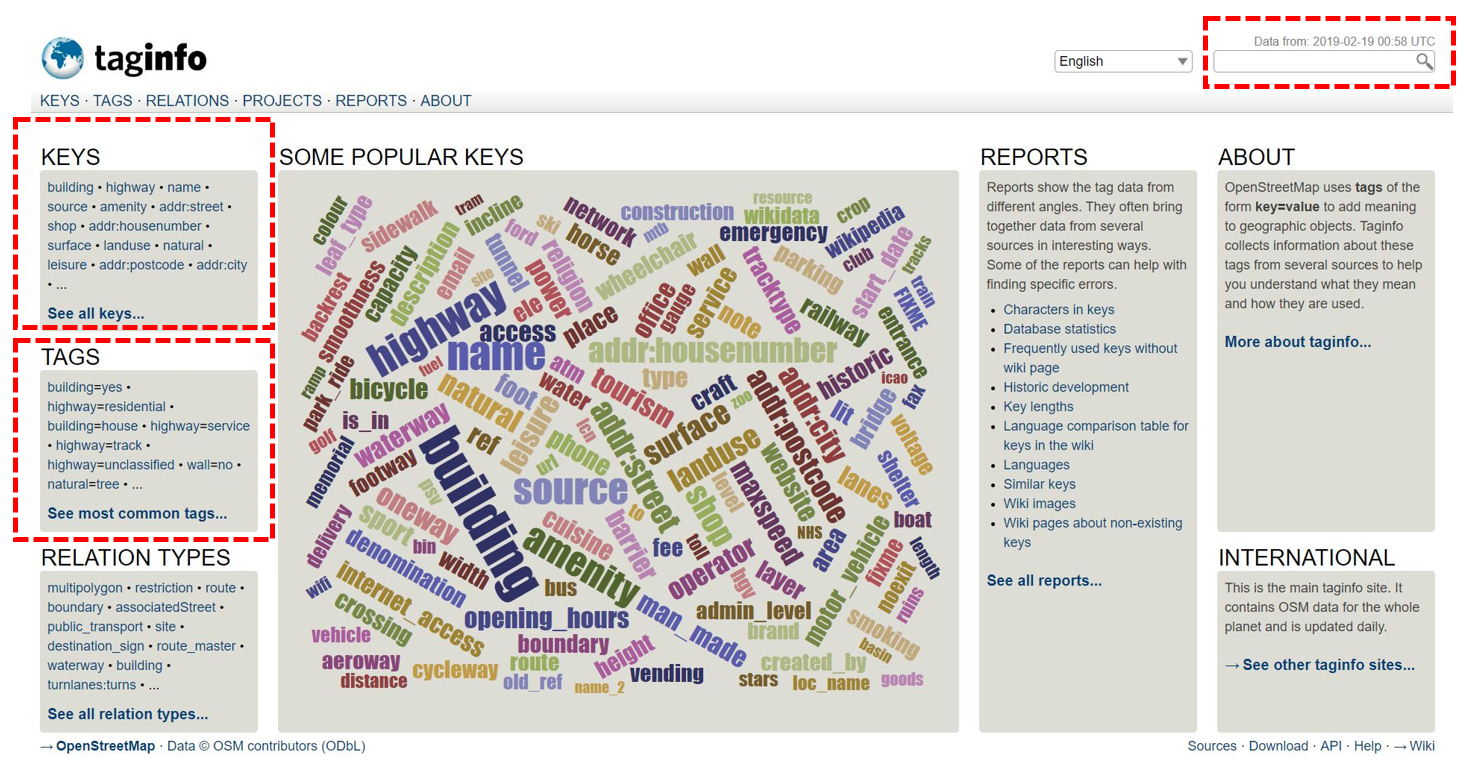
The picture above shows KEYS colom where showing some most searched keys by OpenStreetMap contributor such as building, highway, name, source, etc. Moreover, you also can see combination between certain key and value (tag) which quite common such as building=yes and highway=residential TAGS colom or you can search your key manually in search box at the top right corner on the website page.
For example, if you want to search information about how to put your mapping activity as a source of the object or Level of Certain Building, you can click building option in Keys colom and you will see this:
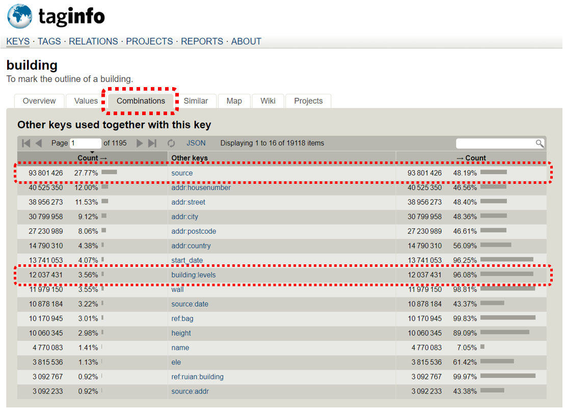
You can choose Combinations tab and you will see some combinations for building key that commonly used by OpenStreetMap contributor. For instance, if you are looking for information about source of building and building level, you can use source and building:levels. Moreover, you can see another combination for key and value related to building. You can see how often the key have been used in OpenStreetMap by look at Count colom. The bigger the number means the key more often and commonly used by OpenStreetMap contributors all over the world.
Notes : key and value in OpenStreetMap HAVE TO BE WRITTEN in English key and value in OpenStreetMap HAVE TO BE WRITTEN in lower case Information interface can be set to show in Bahasa Indonesia on JOSM by editing / make special presets Make new presets will be explained in other module called Making OpenStreetMap Presets
SUMMARY
Congratulation! You have learned about data model in OpenStreetMap . This material is important and really to be understand by OpenStreetMap contributors so you can do your mapping based on international standard from OpenStreetMap community guidelines. Moreover, you also have known about certain websites which can help you to find the information (tag) for you mapping objects such as OSM wiki Map Feature Indonesia, OpenStreetMap Wikipedia page, and Tag Info.