Activations
When a disaster hits, fAIr is used for rapid response: local models are trained on imagery mapped during the activation, then used to speed up feature and damage mapping while volunteers validate the results. This page tracks fAIr disaster activations.
Nepal floods 2026
In August 2026, flash floods and mudslides swept down the Lhende Khola valley into the Bhote Koshi in Rasuwa district. Within 24 hours of the flood, HOT, NAXA and NDRRMA opened the first mapping project. Volunteers mapped from Vantor before-and-after imagery, and two fAIr local models learned from that mapping: one found the buildings, the other scored the damage level per building. Volunteers then validated the AI results.
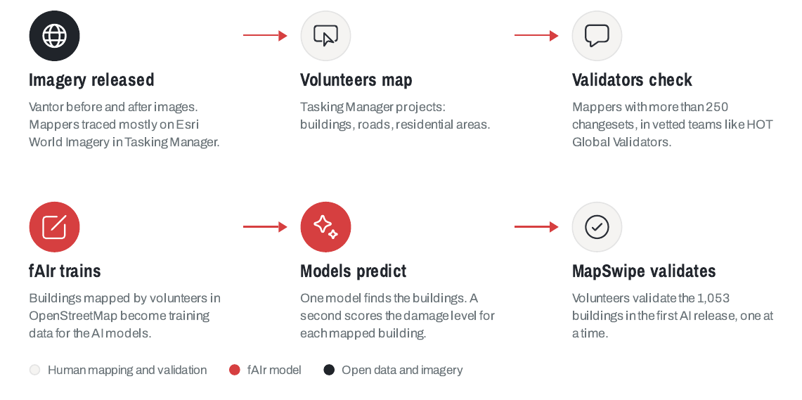
- 338 experienced volunteer mappers added 20,100 buildings to OpenStreetMap.
- 4,170 MapSwipe contributors, counted once per project, validated the AI results in nine projects, with over 423,000 results.
- Two local models trained on buildings mapped by hand during the response, live on Try fAIr.
- Open data on HDX: flood-affected buildings, the river corridor, and the fAIr damage assessment.
Download the Nepal floods workflow (PDF)
Colombia earthquake 2026
On 10 August 2026, a magnitude 7.4 earthquake centred in the Chocó department struck western Colombia, causing widespread destruction in Cali, Pereira, Manizales, Quibdó, and other cities. HOT worked with OSM Colombia, UNGRD, UN Maps, UNDP, and IGAC to define priority areas. Volunteers mapped buildings and roads in the Tasking Manager, fAIr produced building and damage predictions, and MapSwipe volunteers validated the damage predictions.
- More than 450 contributors mapped buildings and roads in OpenStreetMap (as of 8 September 2026).
- 717 MapSwipe contributors, counted once per project, validated the building-damage predictions in two projects, for Viterbo (Caldas) and La Tebaida, with over 49,000 results.
- Open data: OpenStreetMap data on HDX, and fAIr's building and damage predictions for the Pereira area on Hugging Face.
Venezuela earthquake 2026
On 24 June 2026, two earthquakes struck northern Venezuela seconds apart, a magnitude 7.5 shock following a 7.2 foreshock, damaging buildings across Caracas, La Guaira, and the coastal Vargas area. Within 24 hours, fAIr delivered building density, AI-detected building footprints, and building-damage predictions from post-event Vantor imagery to early responders. Volunteers then mapped buildings in OpenStreetMap and validated the damage predictions through MapSwipe.
- 590 contributors mapped around 97,000 building footprints, part of 136,000 OpenStreetMap edits during the response.
- 2,681 MapSwipe contributors, counted once per project, validated the building-damage predictions from fAIr and Microsoft's AI for Good Lab in 23 projects, with over 180,000 results, producing human-validated damage assessments for Caraballeda, La Guaira, and Caracas.
- Validate the results on the MapSwipe project.
- Open data on HDX: building footprints and the building-damage assessment.